TSX-V: HAN

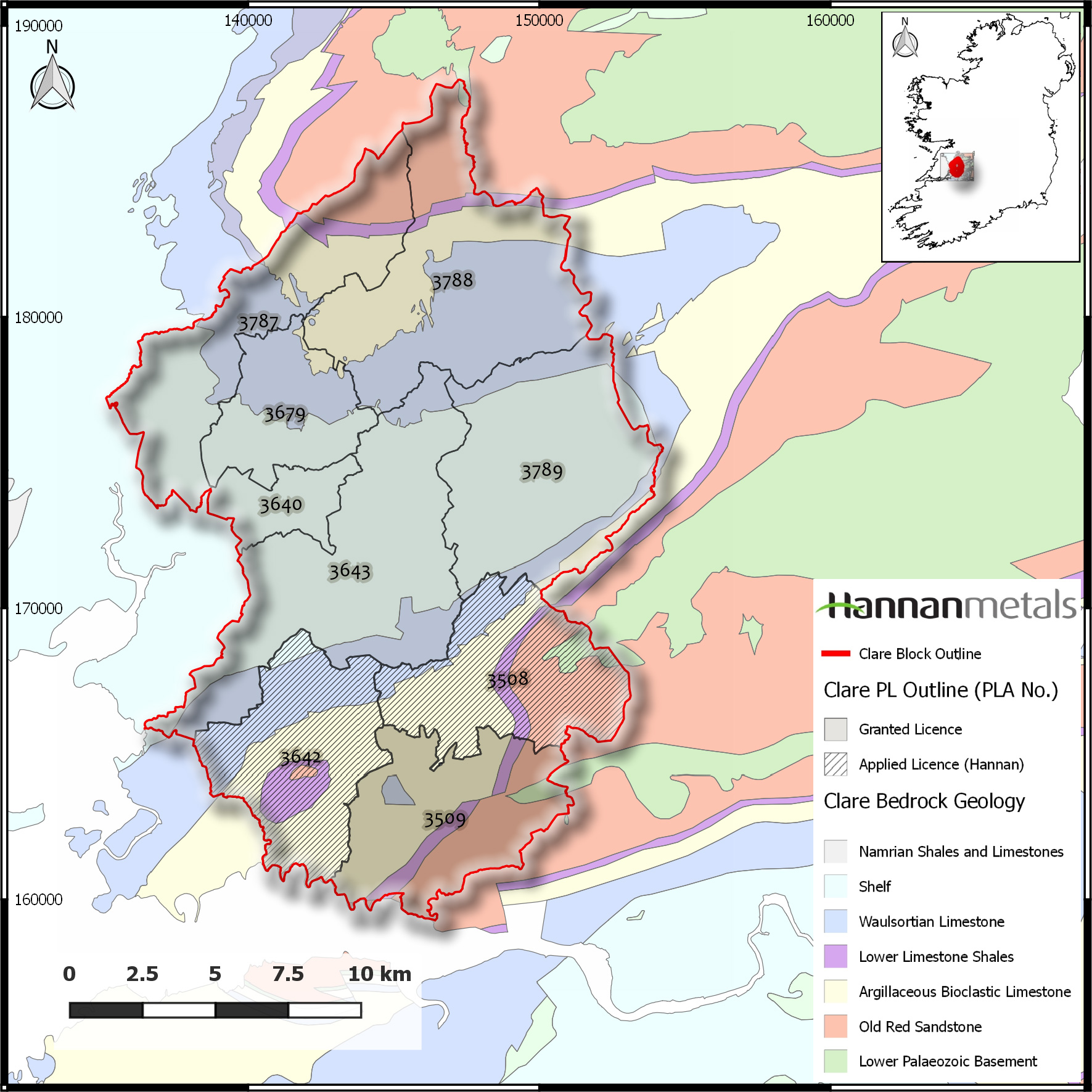
The Clare project consists of 7 Prospecting Licences ("PLs") and two PL applications for a total of 35,444 hectares located in County Clare, Ireland, the western edge of which is 1.5 km east of the town of Ennis. PLs 3509, 3640, 3643, 3679, 3787, 3788 and 3789, are granted and issued by the Exploration and Mining Division (“EMD”) of the Department of Communications, Climate Action and Environment while PLs 3508 and 3642 remain under application. All prospecting licences of the Clare Property are 100% owned Hannan Ireland.
The Kilbricken resource is contained within the broader Clare project area.
The Property is underlain by Upper Devonian (sandstones) to Lower Carboniferous (sandstones and limestones) rocks. The stratigraphy appears simple; beds are the right way up and most of the major units are consistent in thickness across the property, however syn-rift and/or later structures appear to complicate the geological framework. The stratigraphic succession of the Irish Lower Carboniferous is well constrained throughout, with the exception of the uppermost units. The axis of an open syncline runs southwest-northeast through the centre of the Property. Beds dip at between 10 and 15 degrees towards the centre of the syncline. The Lower Carboniferous sequence includes the Waulsortian Limestone, which hosts most of Ireland’s important zinc-lead sulphide deposits, such as the Lisheen (pre-mining resource 18.9 Mt @ 15.0% Zn+Pb) and Galmoy (pre-mining resource of 6.2 Mt @ 12.4% Zn+Pb) deposits. This data has been sourced from the Irish Exploration, Mining Division website http://www.mineralsireland.ie/. The Company has been unable to independently verify the information and states that the information is not necessarily indicative of the mineralization on the Clare Property that is the subject of the technical report.
The Clare Property has a rich history of small scale 19th century mining. Modern exploration efforts from the early-1960’s, by Irish Base Metals, Rio-Finex, Central Mining Finance, Billiton and Belmore Resources Ltd followed up some of these earlier historic mines.
Significant historic exploration on the Property has concentrated on three project areas and on identifying other areas of the Property which have the potential to warrant similar investigation. The project areas are:
There are two known Waulsortian-hosted zinc-lead deposits on the property, the flagship Kilbricken prospect (see below) and the smaller Milltown prospect, where Belmore Resources Ltd (“Belmore”) intersected 13.3m @ 5.8% Pb and 10.5% Zn from 45.4 metres in drill hole 3788/19 in 1994. The lowest part of the sequence is also prospective for copper-silver mineralization and contains numerous copper showings, most notable at Ballyvergin where Irish Base Metals drilled hole BV11 which intersected 31.5m @ 1.0% Cu from 51.7 metres in the 1960s. Given the general flat lying and stratabound nature of mineralization and steep angles of all drillholes mentioned, the true thickness of the mineralized intervals quoted is interpreted to be approximately 95% of the sampled thickness.
In 2008, Belmore, a private Irish company, drill tested the base of the Waulsortian Limestone beneath near-surface sulphidic and calcite veined shelf carbonates at the historic Kilbricken lead mine. The discovery drillhole at Kilbricken, DH04, intersected 10m @ 13.8% Zn, 5.5% Pb, 0.08% Cu, and 62.8g/t Ag from 448.1 metres at the targeted base of Waulsortian Limestone. Given the general flat lying and stratabound nature of mineralization and steep angles of all drillholes mentioned, the true thickness of the mineralized intervals quoted is interpreted to be approximately 95% of the sampled thickness.
After this initial discovery, Lundin Mining Exploration Limited (“Lundin”), an Irish subsidiary of Lundin Mining Corporation (TSX:LUN), joint ventured Kilbricken and the wider tenure package from Belmore. In 2011, Lundin purchased 100% of Belmore. Drilling by Lundin from 2009 to 2012 continued to intersect sulphide mineralization in the hanging wall of the Main Kilbricken fault.
Hannan Metals Ireland Ltd (“Hannan Ireland”) acquired the project from Lundin on September 21, 2016, pursuant to an Assignment Agreement (the “AA”) between the Irish Minister for Communications, Climate Action and Environment, Hannan Ireland and Lundin. Under a separate Asset Purchase Agreement (the “APA”), dated June 3, 2016, Hannan Ireland purchased all exploration data associated with the PLs from Lundin for cash payment of US$1,000,000, which have all been made. Lundin retained a 2% net smelter return royalty on all sales of mineral products extracted from the area of land subject to the PLs, subject to a 0.5% buy back right of Hannan Ireland for US$5,000,000, which must be exercised within one year from the date of commercial production. Hannan Ireland is required to pay Lundin a one-time bonus payment of US$5,000,000 within the earlier of (i) Hannan Ireland’s decision to proceed with mine construction or (ii) within 90 days of the establishment of a commercial financing to finance capital costs for mine construction. Additionally, Hannan Ireland will be required to pay a one-time cash fee of US$2,000,000 less cash payments already made to Lundin, if it transfers its rights to the PLs to an arm’s length party (which excludes Mitchell) for US$10,000,000 or greater within 18 months of the execution of the APA.
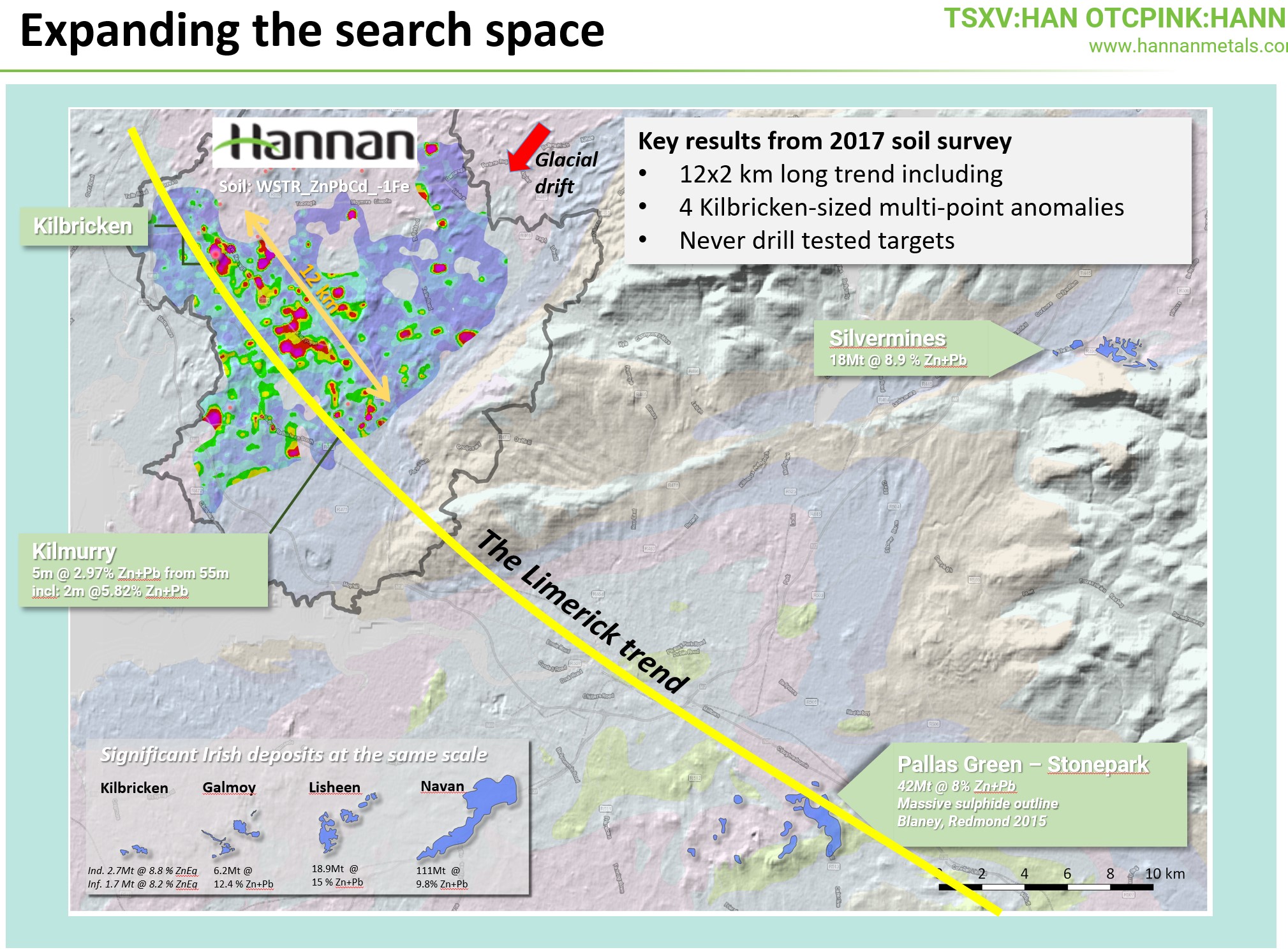
Regional Soil Sampling
Hannan commenced work in late 2016 on the Claire project and in January 2018 announced the results of an extensive 961 sample regional soil geochemical survey covering >200km2 around the Kilbricken deposit and along strike/downdip prospective stratigraphy.. The Kilbricken deposit forms a strong geochemical signature at surface and the geochemical surveys were undertaken to search for new anomalies in a similar geological setting to that of Kilbricken.
Highlights are:
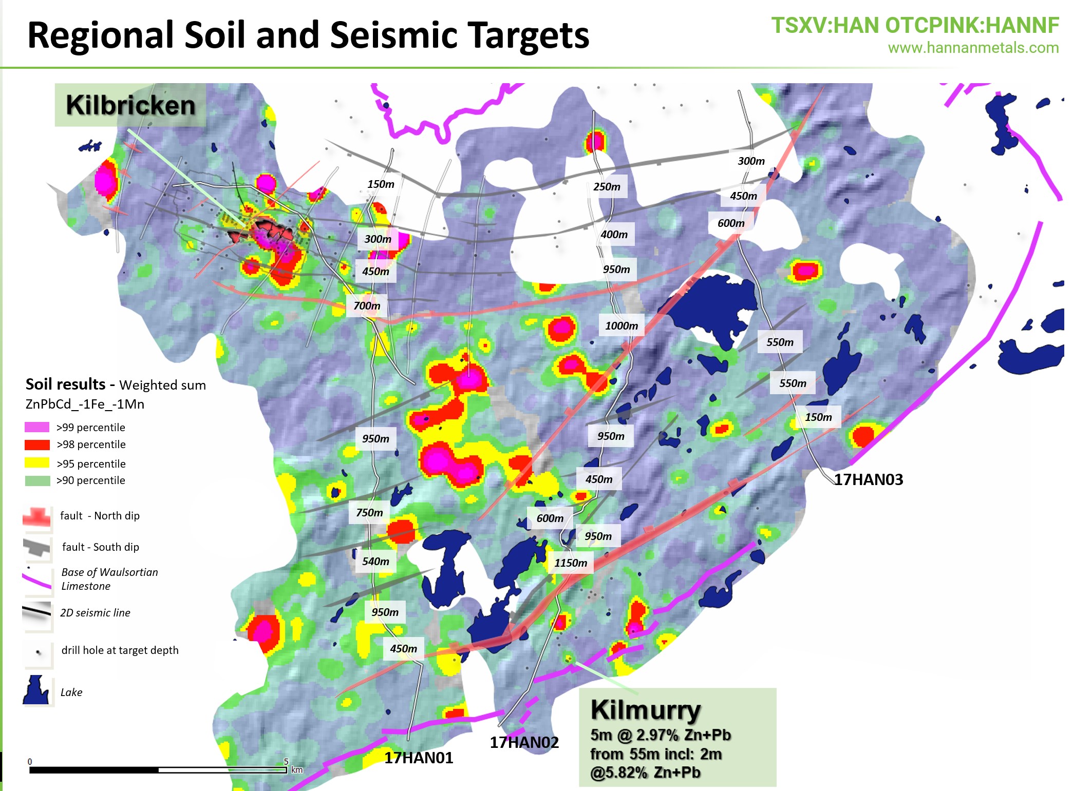
Seismic Survey
During January, 2018 the Company announced completion of a 40.6 line kilometre 2D seismic survey at the Clare Project. The regional seismic survey is a first for the area and has delivered a critical new set of subsurface data across the Company’s 35,444 hectare PLs, which will form the basis for current and future drill targeting and prioritization.
The survey traversed the most prospective parts of the Clare Basin within the Company’s PLs and was used to identify and map geological structures that may host and control base metal mineralization. The Company’s seismic survey propels understanding of the architecture and geological prospectivity of the Clare Basin, in a manner not previously possible.
Initial results of processing and interpretation of the 40.6km seismic survey completed at the Company's Kilbricken zinc-lead-silver prospect and extensive 35,444 hectare Clare project in County Clare, Ireland.
Key points: